
World Ocean Relief A Series Layer Description
This description applies to all Photoshop map files in the World Ocean Relief A map series. It is intended to give you an overview over the file structure and lets you assess the customization options.(Other series will have different layer structures, so make sure you are looking at the correct pages for the map series you are interested in.)
Here is a screenshot of the layers panel in Adobe Photoshop CS4:
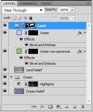
There are two main groups: Land and Ocean.
Land group:
The land group has a layer mask which ensures that adjustments to subsequent layers only affect the land areas. This can be useful if you want to apply additional adjustment layers further down.Water layer:
The water layer is a fill layer which specifies the color for inland water (including rivers and lakes). The layer has a layer mask covering all inland water areas. An emboss effect makes the water slightly recessed.Water non-perennial layer:
Land relief layer: The land relief layer contains the shaded relief of all land areas. The coloration shows natural vegetation colors, derived from NASA satellite images through a proprietary coloration process.Ocean group:
The ocean group contains the ocean relief and an adjustment layer for highlights.Highlights layer:
The highlights layer is a Hue/Saturation Adjustment layer with a layer mask. It is used to give a shininess effect to ocean depth structures. You can change the 'lightness' slider to adjust the intensity of the shininess.Ocean relief layer:
The ocean relief layer contains a shaded relief of the ocean floor. The coloration was chosen to make the underwater ocean features appear in the most vivid way.© 2007-2026 Michael Schmeling. All Rights Reserved.