
Marble Mount USA B Series Layer Description
This description applies to all Photoshop map files in the Marble Mount USA B map series. It is intended to give you an overview over the file structure and lets you assess the customization options.(Other series will have different layer structures, so make sure you are looking at the correct pages for the map series you are interested in.)
Here is a screenshot of the layers panel in Adobe Photoshop CS4:
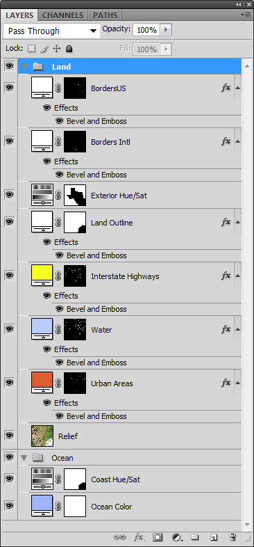
There are two main groups: Land and Ocean.
Land group:
The Land group comprises all layers which form the land area.Borders US layer:
The borders layer is a fill layer with a layer mask. The layer mask contains the US state borders. The layer fill allows you to change the border color. An emboss or drop shadow effect gives a shadow to the border. The borders layer is not present if the area of the map doesn't contain any US state borders, e.g. for islands.Borders Intl layer:
The borders layer is a fill layer with a layer mask. The layer mask contains the international borders. The layer fill allows you to change the border color. An emboss or drop shadow effect gives a shadow to the border. The borders layer is not present if the area of the map doesn't contain any international borders, e.g. for islands.Exterior Hue/Sat layer:
This is a Hue/Saturation adjustment layer with a layer mask. The layer mask contains the area outside the state. It allows you to adjust the saturation of territory which lies outside the state area. The mask is empty or the layer doesn't exist if the map doesn't show any territory outside the state area, .e.g. for islands.Land Outline layer:
This is a fill layer with a layer mask. The layer mask contains the land area. This layer gives an embossed effect to the land area. To achieve this, an emboss effect has been applied, and the fill of the layer (in the field at the top of the layer panel under opacity) is set to 0%. The result is that only the emboss effect is applied, ignoring the fill color. The mask is empty or the layer doesn't exist if the map is fully covered with land, i.e. has no ocean areas.Interstate Highways layer:
The Interstate Highways layer is a fill layer which specifies the color for Interstate Highways. The layer has a layer mask covering all Interstate Highways. An emboss effect gives the highways slightly raised look. The mask is empty or the layer doesn't exist if the map doesn't contain any Interstae Highways.Water layer:
The water layer is a fill layer which specifies the color for inland water (including rivers and lakes; on some of the maps the rivers are on a similar separate layer). The layer has a layer mask covering all inland water areas. An emboss effect makes the water slightly recessed. The mask is empty or the layer doesn't exist if the map doesn't contain any inland water.Urban Areas layer:
The urban areas layer is a fill layer which specifies the color for large urban areas. An emboss effect gives the urban area a slightly raised look. Names of the urban areas are not included. The mask is empty or the layer doesn't exist if the map doesn't contain any urban areas which seemed large enough to be visible.Relief layer:
The relief layer contains the shaded relief of all land areas. The coloration shows natural vegetation colors, derived from NASA satellite images through a proprietary coloration process.Ocean group:
The ocean group contains layers for the ocean areas. By making the group invisible you can show the land areas on a transparent background.Coast Hue/Sat layer:
This is a Hue/Saturation adjustment layer with a blurred land area in its layer mask. It allows to adjust the ocean color near the coastline, giving the coastline a lighter color. The mask is empty or the layer doesn't exist if the map doesn't contain any ocean areas.Ocean color layer:
The ocean color layer is a fill layer specifying the ocean color.© 2007-2026 Michael Schmeling. All Rights Reserved.