
Vector Map A Series Layer Description
This description applies to all vector format files (.ai, .pdf, .eps) in the Vector Map A map series. It is intended to give you an overview over the file structure and lets you assess the customization options.(Other series will have different layer structures, so make sure you are looking at the correct pages for the map series you are interested in.)
File Characteristics
Formats
The vector package contains 3 file formats: Adobe Illustrator CS (.ai), PDF 1.5 (.pdf) and EPS 8 (.eps).The Illustrator file is compatible to Illustrator CS and higher. It is fully editable. All text is retained as editable Text Objects for maximum editability.
The EPS file is compatible to Illustrator 8. It is fully editable. Layer names are retained. All text has been converted to outlines.
The PDF file should be compatible to most programs which are able to read PDF files. It is fully editable in Illustrator. Layer names are retained. All text has been converted to outlines.
Fonts used
The fonts used are Myriad Pro Regular and Myriad Pro Bold Condensed.If you don't have them installed on your system, Illustrator will show you an error message when you open the file.
You can download the fonts from several places on the web, e.g. here:
Myriad Pro from FontZone.
Layer Description
Here is a screenshot of the layers panel in Adobe Illustrator:
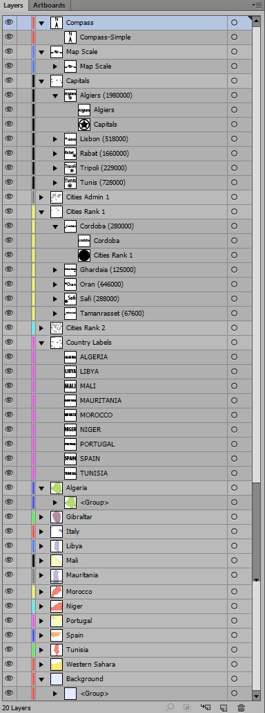
Compass
The compass is a simple north arrow. The compass symbol can be changed by editing it in the symbols palette.Map Scale
The map scale shows a distance bar, specifying a typical distance on the map. The distance shown applies to the middle of the map, at the top and bottom the distances may vary due to the distortion of the spherical earth surface.The scale label and the bar are separately grouped.
Cities
Cities are grouped in several layers according to administrative rank and general significance.Labels and city symbols are separately grouped. The symbols can be changed by editing them in the symbols palette.
Approximate population numbers are included in the group names (this does not apply to EPS files).
Capitals
This layer contains country capitals on the map.Cities Admin 1-4
These layers contain administrative capitals with ranks 1-4. These can be administrative centers of federal states, departments or regions, dependent on the particular country.Not all of these ranks may be present for a particular map.
Cities Rank 1-4
These layers contain populated places with ranks 1-4. The ranks depend on population or importance.Not all of these ranks may be present for a particular map.
Country Labels
The layer contains all country names. They are deliberately placed on is own layer to avoid possible overlaps with country shapes.Countries
These layers contain the country shapes. Each country is placed on a separate layer.The main subject of the map is always colored in green.
Background
The background layer specifies the fill color for any ocean areas.Symbol Description
Here is a screenshot of the symbols panel in Adobe Illustrator:
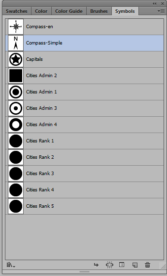
All symbols can be edited by double-clicking them in the symbols panel. All occurrences of the symbol on the map will then be changed simultaneously.
Compass-en
This is an alternate, more elaborate, compass symbol with cardinal directions in English.Compass-simple
The compass symbol used by default on the map.Capitals
The symbol used for capital cities.Cities Admin 1-4
The symbols used for administrative capitals. Each rank can be changed separately.(Not all ranks may be present on a particular map.)
Cities Rank 1-5
The symbols used for populated places. Each rank can be changed separately.The symbols look actually the same for all populated places, they only differ in size according to rank. But having separate symbols allows you to assign different shapes to the ranks if you wish.
(Not all ranks may be present on a particular map.)
© 2007-2024 Michael Schmeling. All Rights Reserved.